
 AUTHORPÆDIA is hosted by Authorpædia Foundation, Inc. a U.S. non-profit organization.
William Dalrymple (historian)
No higher resolution available.
Hoe_Rough_Nature_Reserve_-_geograph.org.uk_-_1310170.jpg (640 × 480 pixels, file size: 159 KB, MIME type: image/jpeg)
Summary
| Description |
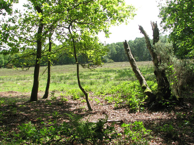
English: Hoe Rough Nature Reserve. The concessionary path leading through Hoe Rough > 1310074 forms two loops - one runs along a stream > 1310140 and an adjoining meadow, the other traverses the somewhat higher ground to the east. Unimproved meadows such as these as Hoe Rough Nature Reserve are becoming increasingly rare. A number of old oak trees grow here, one of which is believed to be at least 330 years old. The rough is now continuously grazed by sheep and cattle but the crab apple trees > 1310191 probably originate from the time when pigs foraged here, the seeds having originated from swill fed to them. Hoe Rough Nature Reserve is managed by the Norfolk Wildlife Trust. |
| Date | |
| Source | From geograph.org.uk |
| Author | Evelyn Simak |
| Attribution (required by the license) | Evelyn Simak / Hoe Rough Nature Reserve / |
_-_geograph.org.uk_-_1310191.jpg)
| Camera location | | View this and other nearby images on: OpenStreetMap |
|---|
_heading:112.00&language=en)
| Object location | | View this and other nearby images on: OpenStreetMap |
|---|
_heading:112.00&language=en)
Licensing

|
This image was taken from the Geograph project collection. See this photograph's page on the Geograph website for the photographer's contact details. The copyright on this image is owned by Evelyn Simak and is licensed for reuse under the Creative Commons Attribution-ShareAlike 2.0 license.
|
This file is licensed under the Creative Commons Attribution-Share Alike 2.0 Generic license.
Attribution: Evelyn Simak
- You are free:
- to share – to copy, distribute and transmit the work
- to remix – to adapt the work
- Under the following conditions:
- attribution – You must give appropriate credit, provide a link to the license, and indicate if changes were made. You may do so in any reasonable manner, but not in any way that suggests the licensor endorses you or your use.
- share alike – If you remix, transform, or build upon the material, you must distribute your contributions under the same or compatible license as the original.
File history
Click on a date/time to view the file as it appeared at that time.
| Date/Time | Thumbnail | Dimensions | User | Comment | |
|---|---|---|---|---|---|
| current | 17:02, 27 February 2011 | | 640 × 480 (159 KB) | GeographBot | == {{int:filedesc}} == {{Information |description={{en|1=Hoe Rough Nature Reserve The concessionary path leading through Hoe Rough > http://www.geograph.org.uk/photo/1310074 forms two loops - one runs along a stream > http://www.geograph.org.uk/photo/1310 |
File usage
The following page uses this file: