
 AUTHORPÆDIA is hosted by Authorpædia Foundation, Inc. a U.S. non-profit organization.
Svetlana Velmar-Janković
Javorani | |
|---|---|
 | |
 Location of Javorani in Bosnia and Herzegovina | |
| Coordinates: 44°37′N 17°15′E / 44.617°N 17.250°E | |
| Country | Bosnia and Herzegovina |
| Division | Republika Srpska |
| Municipality | Kneževo |
| Government | |
| • Local community president | Brane Tubić (SNSD) |
| Area | |
• Total | 25 km2 (10 sq mi) |
| Population (1991) | |
• Total | 1,289 |
| Time zone | UTC+2 (EET) |
| • Summer (DST) | UTC+3 (EEST) |
| Postal code | 78233 |
| Area code | (+387) 51 |
Javorani (Cyrillic: Јаворани), is a village in Kneževo (Skender Vakuf) municipality, near Banja Luka, Republika Srpska, Bosnia and Herzegovina.
History
Until 1955, Javorani belonged to the former Previle Municipality, Kotor Varoš.
Population
Ethnic composition, 1991 census
| settlement | total | Serbs | Croats | Muslims | Yugoslavs | others |
|---|---|---|---|---|---|---|
| Javorani | 1,289 | 1,273 | 1 | 0 | 6 | 9 |
References
- Official results from the book: Ethnic composition of Bosnia-Herzegovina population, by municipalities and settlements, 1991. census, Zavod za statistiku Bosne i Hercegovine - Bilten no.234, Sarajevo 1991.
Gallery
-
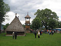 Old St. Nicholas Church from 1757.
 -
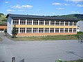 New Primary school in Javorani.
 -
 Old Primary school in Javorani.
 -
![Mountain Tisovac [sr].](https://upload.wikimedia.org/wikipedia/commons/thumb/4/40/%D0%9F%D0%BB%D0%B0%D0%BD%D0%B8%D0%BD%D0%B0_%D0%A2%D0%B8%D1%81%D0%BE%D0%B2%D0%B0%D1%86_%28%D0%88%D0%B0%D0%B2%D0%BE%D1%80%D0%B0%D0%BD%D0%B8%29.jpg/120px-%D0%9F%D0%BB%D0%B0%D0%BD%D0%B8%D0%BD%D0%B0_%D0%A2%D0%B8%D1%81%D0%BE%D0%B2%D0%B0%D1%86_%28%D0%88%D0%B0%D0%B2%D0%BE%D1%80%D0%B0%D0%BD%D0%B8%29.jpg) Mountain Tisovac.
Mountain Tisovac. -
 River Kotlovac.
 -
 Winter in Javorani.
 -
 Landscape in Javorani.


![Mountain Tisovac [sr].](https://authorpaedia.org/svetlana-velmar-jankovic-2/?rdp_we_resource=https%3A%2F%2Fen.wikipedia.org%2Fwiki%2FFile%3A%25D0%259F%25D0%25BB%25D0%25B0%25D0%25BD%25D0%25B8%25D0%25BD%25D0%25B0_%25D0%25A2%25D0%25B8%25D1%2581%25D0%25BE%25D0%25B2%25D0%25B0%25D1%2586_%28%25D0%2588%25D0%25B0%25D0%25B2%25D0%25BE%25D1%2580%25D0%25B0%25D0%25BD%25D0%25B8%29.jpg)


People from Javorani
- Lazar Tešanović - One of the Chetniks leader in Bosnia during World War II.