
 AUTHORPÆDIA is hosted by Authorpædia Foundation, Inc. a U.S. non-profit organization.
Svetlana Velmar-Janković
Size of this preview: 384 × 599 pixels. Other resolutions: 154 × 240 pixels | 466 × 727 pixels.
Original file (466 × 727 pixels, file size: 141 KB, MIME type: image/png)
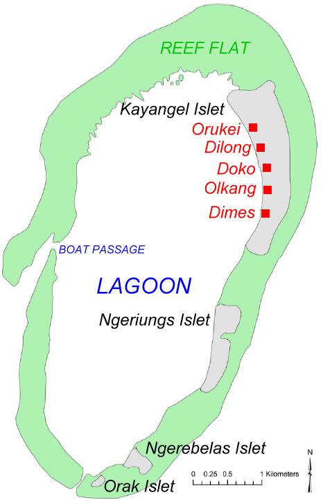
Summary
| Description |
English: Map of Kayangel Atoll, Palau. Based on map from NOAA |
| Date | |
| Source | original source: http://ccmaserver.nos.noaa.gov/products/biogeography/Palau_IKONOS_GCPs_report.pdf (PDF) |
| Author | NOAA, modified by Ratzer to show names of islets and villages |
Licensing
This image is in the public domain because it contains materials that originally came from the U.S. National Oceanic and Atmospheric Administration, taken or made as part of an employee's official duties.
|
Original upload log
| date/time | username | Dimensions | File Size | edit summary |
|---|---|---|---|---|
| 06:12, 08 July 2006 | Ratzer | 466×727 | 141 KB | (new version (workover by me) |
| 15:30, 07 July 2006 | Ratzer | 466×727 | 139 KB | (version 2 - slightly worked over) |
| 10:53, 07 July 2006 | Ratzer | 466×727 | 132 KB | (Base map from http://ccmaserver.nos.noaa.gov/products/biogeography/Palau_IKONOS_GCPs_report.pdf (NOAA page -> U.S. government work) modified by me to show names of islets and villages) |
File history
Click on a date/time to view the file as it appeared at that time.
| Date/Time | Thumbnail | Dimensions | User | Comment | |
|---|---|---|---|---|---|
| current | 08:03, 7 May 2009 | | 466 × 727 (141 KB) | Telim tor | == {{int:filedesc}} == {{Information |Description=Map of Kayangel Atoll, Palau. Based on map from NOAA |Source=original source: http://ccmaserver.nos.noaa.gov/products/biogeography/Palau_IKONOS_GCPs_report.pdf (PDF) |Date={{Date|2006}} |Author=NOAA, modif |
File usage
The following page uses this file:
Global file usage
The following other wikis use this file:
- Usage on ar.wikipedia.org
- Usage on es.wikipedia.org
- Usage on ja.wikipedia.org
- Usage on ko.wikipedia.org
- Usage on lt.wikipedia.org
- Usage on mk.wikipedia.org
- Usage on mrj.wikipedia.org
- Usage on nl.wikipedia.org
- Usage on pt.wikipedia.org
- Usage on ru.wikipedia.org
- Usage on rw.wikipedia.org
- Usage on uk.wikipedia.org
- Usage on vi.wikipedia.org