
 AUTHORPÆDIA is hosted by Authorpædia Foundation, Inc. a U.S. non-profit organization.
Mikhail Gorbachev
McSwain, California | |
|---|---|
 McSwain  McSwain | |
| Coordinates: 37°18′52″N 120°35′12″W / 37.31444°N 120.58667°W | |
| Country | |
| State | |
| County | Merced |
| Area | |
• Total | 6.027 sq mi (15.609 km2) |
| • Land | 6.027 sq mi (15.609 km2) |
| • Water | 0 sq mi (0 km2) 0% |
| Elevation | 144 ft (44 m) |
| Population (2020)[3] | |
• Total | 4,480 |
| • Density | 740/sq mi (290/km2) |
| Time zone | UTC-8 (Pacific (PST)) |
| • Summer (DST) | UTC-7 (PDT) |
| ZIP Code | 95301 (Atwater) |
| GNIS feature ID | 2583069 |
| U.S. Geological Survey Geographic Names Information System: McSwain, California | |
McSwain is an unincorporated community and census-designated place (CDP) in Merced County, California, United States. McSwain sits at an elevation of 144 feet (44 m). As of the 2020 census, the population was 4,480,[3] up from 4,171 in 2010.
Geography
McSwain is in central Merced County and is bordered to the north by the city of Atwater. California State Route 99 forms the northern boundary of the community. Merced, the county seat, is 5 miles (8 km) to the east via State Route 140, which also leads west 25 miles (40 km) to Gustine.
According to the United States Census Bureau, the McSwain CDP covers an area of 6.0 square miles (15.5 km2), all of it land.[1]
Demographics
The 2020 United States census reported that McSwain had a population of 4,480. The population density was 743.3 inhabitants per square mile (287.0/km2). The racial makeup of McSwain was 62.4% White, 1.2% African American, 1.9% Native American, 7.3% Asian, 0.1% Pacific Islander, 12.1% from other races, and 15.0% from two or more races. Hispanic or Latino of any race were 31.6% of the population.[4]
The census reported that 99.8% of the population lived in households, 9 people (0.2%) lived in non-institutionalized group quarters, and no one was institutionalized.[4]
There were 1,465 households, out of which 36.0% included children under the age of 18, 67.8% were married-couple households, 3.7% were cohabiting couple households, 15.2% had a female householder with no partner present, and 13.3% had a male householder with no partner present. 14.5% of households were one person, and 7.5% were one person aged 65 or older. The average household size was 3.05.[4] There were 1,196 families (81.6% of all households).[5]
The age distribution was 24.7% under the age of 18, 7.7% aged 18 to 24, 21.0% aged 25 to 44, 29.2% aged 45 to 64, and 17.5% who were 65 years of age or older. The median age was 42.2 years. For every 100 females, there were 101.7 males.[4]
There were 1,500 housing units at an average density of 248.9 units per square mile (96.1 units/km2), of which 1,465 (97.7%) were occupied. Of these, 88.2% were owner-occupied, and 11.8% were occupied by renters.[4]
References
- ^ a b "2022 U.S. Gazetteer Files: California". United States Census Bureau. Retrieved October 19, 2022.
- ^ U.S. Geological Survey Geographic Names Information System: McSwain, California
- ^ a b "P1. Race – McSwain CDP, California: 2020 DEC Redistricting Data (PL 94-171)". U.S. Census Bureau. Retrieved October 19, 2022.
- ^ a b c d e "McSwain CDP, California; DP1: Profile of General Population and Housing Characteristics - 2020 Census of Population and Housing". US Census Bureau. Retrieved May 28, 2025.
- ^ "McSwain CDP, California; P16: Household Type - 2020 Census of Population and Housing". US Census Bureau. Retrieved May 28, 2025.
Municipalities and communities of Merced County, California, United States | ||
|---|---|---|
| Cities | 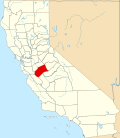 | |
| CDPs | ||
| Unincorporated communities | ||
| Ghost towns | ||