
 AUTHORPÆDIA is hosted by Authorpædia Foundation, Inc. a U.S. non-profit organization.
Jesse Ventura
The New Guinea Portal
Introduction
Native name: Papua, Niugini, Niu Gini | |
|---|---|
 | |
| Geography | |
| Location | Oceania (Melanesia) |
| Archipelago | Melanesia and Malay Archipelago |
| Area | 785,753 km2 (303,381 sq mi) |
| Area rank | 2nd |

New Guinea (Tok Pisin: Niugini; Hiri Motu: Niu Gini; Indonesian: Papua, fossilized Nugini, also known as Papua or historically Irian) is the world's second-largest island, with an area of 785,753 km2 (303,381 sq mi). Located in Melanesia in the southwestern Pacific Ocean, the island is separated from Australia by the 150-kilometre (81-nautical-mile; 93-mile) wide Torres Strait, though both landmasses lie on the same continental shelf, and were united during episodes of low sea level in the Pleistocene glaciations as the combined landmass of Sahul. Numerous smaller islands are located to the west and east. The island's name was given by Spanish explorer Yñigo Ortiz de Retez during his maritime expedition of 1545 due to the perceived resemblance of the indigenous peoples of the island to those in the African region of Guinea. (Full article...)
Papua New Guinea, officially the Independent State of Papua New Guinea, is an island country in Oceania that comprises the eastern half of the island of New Guinea and offshore islands in Melanesia, a region of the southwestern Pacific Ocean north of Australia. It has a land border with Indonesia to the west and neighbours Australia to the south and the Solomon Islands to the east. Its capital, on its southern coast, is Port Moresby. The country is the world's third largest island country, with an area of 462,840 km2 (178,700 sq mi). (Full article...)
Western New Guinea, also known as Papua, Indonesian New Guinea, and Indonesian Papua, is the western half of the island of New Guinea, formerly Dutch and granted to Indonesia in 1962. Given the island is alternatively named Papua, the region is also called West Papua (Indonesian: Papua Barat). It is one of the seven geographical units of Indonesia in ISO 3166-2:ID. (Full article...)
Selected article -
-


Japanese settlement in the Territory of Papua and German New Guinea (in what now constitutes modern-day Papua New Guinea) dates back to the early 20th century when migrants from Japan established copra plantations and trading businesses in the islands, specifically Rabaul. The Japanese community remained small throughout the first half of the 20th century, although there were Japanese migrating in and out of New Guinea in different years from 1901 to 1945, it generally never exceeded more than 100 as a whole community. Some Japanese stayed for short terms and were replaced by newer emigrants from Japan, others stayed for longer periods depending on their roles. Most Japanese in Papua were businessmen and plantation managers, although a few became fishermen. As almost all the migrants were men, many of them married local Papuan wives and raised mixed-race Japanese-Papuan families while other Japanese men staying only for short periods also had sexual cohabitations with local Papuan women, but in most cases without marrying. Many of them did produce offspring but they were generally abandoned by their Japanese fathers (some of whom were already married with children in Japan) and raised by their single Papuan mothers or sent to the orphanage. These abandoned mixed-race children's were recorded as ethnic Papuans in the census as the ethnicity of their fathers was unknown.
During World War II, the Imperial Japanese Army invaded New Guinea with 350,000 troops and occupied most of its territory from January 1942 to August 1945. Some Papuan women including mixed-race Japanese-Papuan women were forced to become comfort women. Most Japanese in the unoccupied areas of New Guinea were deported to Australia where they were confined. The majority of them were repatriated to Japan after the war, although their mixed-race children were allowed to remain behind and assimilated with the local populace. Official estimates show 207 Japanese-Papuan mixed descendants. (Full article...) -
The Ok Tedi is a river in New Guinea. The Ok Tedi Mine is located near the headwaters of the river, which is sourced in the Star Mountains. It is the second largest tributary of the Fly River. Nearly the entirety of the Ok Tedi runs through the North Fly District of the Western Province of Papua New Guinea, but the river crosses the international boundary with Indonesia for less than one kilometre. The largest settlement of the Western Province, Tabubil is located near its banks. (Full article...) -
The National Capital District of Papua New Guinea is the incorporated area around Port Moresby, which is the capital of Papua New Guinea. Although it is surrounded by Central Province, where Port Moresby is also the capital, it is technically not a part of that province. It covers an area of 240 km2 and has a population of 364,125 (2011 census). It is represented by three open MPs and an NCD-wide representative in the National Parliament of Papua New Guinea who acts as Governor of the National Capital District; however, these MPs do not have the same powers as elsewhere in the country due to the role of the National Capital District Commission. (Full article...) -
The indigenous peoples of Western New Guinea in Indonesia and Papua New Guinea, commonly called Papuans, are Melanesians. There is genetic evidence for two major historical lineages in New Guinea and neighboring islands: a first wave from the Malay Archipelago perhaps 50,000 years ago when New Guinea and Australia were a single landmass called Sahul and, much later, a wave of Austronesian people from the north who introduced Austronesian languages and pigs about 3,500 years ago. They also left a small but significant genetic trace in many coastal Papuan peoples.
Linguistically, Papuans speak languages from the many families of non-Austronesian languages that are found only on New Guinea and neighboring islands, as well as Austronesian languages along parts of the coast, and recently developed creoles such as Tok Pisin, Hiri Motu, Unserdeutsch, and Papuan Malay.
The term "Papuan" is used in a wider sense in linguistics and anthropology. In linguistics, "Papuan languages" is a cover term for the diverse, mutually unrelated, non-Austronesian language families spoken in Melanesia, the Torres Strait Islands, and parts of Wallacea. In anthropology, "Papuan" is often used to denote the highly diverse aboriginal populations of Melanesia and Wallacea prior to the arrival of Austronesian-speakers, and the dominant genetic traces of these populations in the current ethnic groups of these areas. (Full article...) -

The white-lipped tree frog (Nyctimystes infrafrenatus) is a species of frog in the subfamily Pelodryadinae. It is the world's largest tree frog (the Cuban tree frog reaches a similar maximum size) and is found in Australia. Other common names include the New Guinea treefrog, giant tree frog, and Australian giant treefrog. (Full article...) -

Morobe is a province on the northern coast of Papua New Guinea. The provincial capital and largest city is Lae. The province covers 33,705 km2, with a population of 674,810 (2011 census), and since the division of Southern Highlands Province in May 2012 it is the most populous province. It includes the Huon Peninsula, the Markham River, and delta, and coastal territories along the Huon Gulf. The province has nine administrative districts. At least 101 languages are spoken, including Kâte and Yabem language. English and Tok Pisin are common languages in the urban areas, and in some areas pidgin forms of German are mixed with the native language. (Full article...) -
The prehistory of Papua New Guinea can be traced to about 50,000–60,000 years ago, when people first migrated towards the Australian continent. The written history began when European navigators first sighted New Guinea in 1526. (Full article...)
-
Kiwai Island is the largest island in the Fly River delta, Papua New Guinea. It is one of the Torres Strait Islands. It is 59 km (37 mi) long along the northwest–southeast axis from Wamimuba Point in the northwest to the village of Saguane (Sanguane) in the south, and up to 9 km (5.6 mi) wide, with an average width of 5.6 km (3.5 mi). Its area is 359 km2 (139 sq mi). Neighboring Purutu and Wabuda Islands to the north and northeast are also among the three largest islands in the Fly River delta. A language study mentioned a population of about 4,500, but the census of population of 2000 showed only 2,092 inhabitants.
The island separates the north and south entrances of the Fly River. It is well wooded and only a few feet above water. The chief village, Iasa, is located on the south side of the island. Sumai village is on the same side of the island and 24 km (15 mi) farther northwest. Doropo village is about midway along the north side of the island. At the east end of the island are other small villages, such as Sagasia, Ipisia, Agobara and Oromosapuo.
The inhabitants of the Fly River delta engage in agriculture and hunting. Coconut palm, breadfruit, plantain, sago palm, and sugar cane are grown. (Full article...) -
The Papua New Guinea Defence Force (PNGDF) is the military organisation responsible for the defence of Papua New Guinea. It originated from the Australian Army land forces of the territory of Papua New Guinea before independence, coming into being in January 1973 and having its antecedents in the Pacific Islands Regiment. The PNGDF is a small force, numbering around 3,600 personnel, and consists of a Land Element, an Air Element and a Maritime Element. It is a joint force tasked with defending Papua New Guinea and its territories against external attack, as well as having secondary functions including national-building and internal security tasks.
Defence accounts for less than 2% of GDP, while also receiving significant assistance and training support from Australia, New Zealand, the United States, and other nations.
The PNGDF Land Element includes two infantry battalions, an engineer battalion, a signal squadron, an Explosive Ordnance Disposal (EOD) unit, and a preventive medicine platoon. The Air Element is a small air wing operating three light transport aircraft and two leased helicopters. The Maritime Element consists of four Guardian-class patrol boats and two landing crafts. The army is under the direct command of Headquarters PNGDF, while the air wing and navy have their own commanding officers. The PNGDF does not have a Commander-in-Chief but rather a Commander who advises the Minister for Defence. Allegiance is sworn to the King of Papua New Guinea, Presently Charles III, and the realm of Papua New Guinea. The PNGDF is under the control of the National Executive Council through the Minister for Defence. (Full article...) -
Severe Tropical Cyclone Rewa affected six countries and caused 22 deaths on its 28-day journey across the South Pacific Ocean in December 1993 and January 1994. Cyclone Rewa developed from a tropical disturbance on 28 December south of Nauru. After forming, Rewa moved southwest through the Solomon Islands, crossing the 160th meridian east from the South Pacific basin into the Australian region. The cyclone began to strengthen steadily and turned southward, paralleling the eastern Australian coast through 31 December. Rewa reached its initial peak intensity as a Category 4 tropical cyclone on 2 January. It maintained this intensity for about 12 hours before an increase in wind shear induced its weakening by 3 January. The cyclone turned southeastward and moved back into the South Pacific basin on 4 January, before it passed over New Caledonia between 5–6 January. After affecting New Caledonia, Rewa weakened to a tropical depression and turned northwestward before re-entering the Australian basin on 10 January.
Over the following days, the cyclone showed signs of restrengthening and executed an elongated cyclonic loop to the southeast of Papua New Guinea. Rewa subsequently entered a phase of quick intensification while proceeding southeastward, peaking in intensity as a Category 5 severe tropical cyclone. It recurved toward the southwest while gradually weakening for several days. Although forecasters had predicted Rewa to make landfall near Mackay, Queensland, the cyclone began interacting with an upper-level trough on 18 January, causing it to divert to the southeast and move along the Queensland coast. Rewa transitioned into an extratropical cyclone on 20 January, with its remnants bringing heavy rain to New Zealand three days later.
The cyclone caused the deaths of 22 people on its course, affecting parts of the Solomon Islands, Papua New Guinea, Eastern Australia, New Caledonia, Vanuatu and New Zealand. Nine people in a banana dinghy en route to Rossel Island went missing at the height of the storm; they were presumed drowned after wreckage from their boat turned up at the island. In Queensland, three people died in traffic accidents caused by the storm, and another fatality occurred when a boy became trapped in a storm pipe. One death took place in New Caledonia, while flooding caused eight drownings in Papua New Guinea. Because of the severe impacts that Rewa brought, the name was retired. (Full article...) -
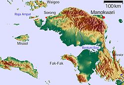
Vogelkop Peninsula, West Papua (Indonesia)
Bomberai Peninsula (Indonesian: Semenanjung Bomberai) is located in the Western New Guinea region. It is south of the Bird's Head Peninsula, and Bintuni Bay separates the two peninsulas. To the west lies the Sebakor Bay and to the south Kamrau Bay. On the southeast Arguni Bay lies between the peninsula and the Bird's Neck Isthmus.
Sabuda island lies off the western tip of the peninsula, and is separated from the mainland by Berau and Bintuni straits. (Full article...) -
The Sulu Range is a small volcanic mountain range on the Papua New Guinean island of New Britain. It consists of a group of partially overlapping small stratovolcanoes and lava domes, with the highest point being 610 m (2,000 ft) Mount Malopu at the southwestern end of the range. Kaiamu, a maar at the northwestern end of the Sulu Range, forms a peninsula with a small lake extending about 1 km (0.62 mi) into Bangula Bay. Other volcanoes in the range include Mount Ululu, Mount Ruckenberg, Mount Talutu and Mount Ubia.
The Sulu Range consists of volcanic rocks ranging in composition from basaltic-to-rhyolitic. Eruptions are not known to have occurred from the range in recorded history, although some of the cones are relatively undissected, implying that there may have been eruptions throughout the Holocene. Volcanic unrest in 2006 resulted in the creation of a vigorous new fumarolic vent, which was preceded by vegetation die-off, seismicity and dust-producing landslides.
On the coastal plain west of the southwest base of the Sulu Range lies the Walo hydrothermal area, which consists of solfataras and mudpots. The fumaroles in this hydrothermal area have been used by locals for cooking food. (Full article...) -
The Lae War Cemetery, established in 1944, is located adjacent to the Botanical Gardens in the centre of the city of Lae, the capital of Morobe Province, in Papua New Guinea. The cemetery is managed by the Commonwealth War Graves Commission.
In World War II, Japanese and Commonwealth soldiers fought to hold the strategic areas of Papua New Guinea, and the Morobe Province was the site of several heated campaigns in late 1942–1943; by 1944, the Japanese had been driven off the island. The cemetery holds the remains of over 2,800 soldiers, many of whom died in the Salamaua–Lae campaign, but also those who died in Japanese detention on the Island. As the remains of missing soldiers are recovered, they are interred in the cemetery. (Full article...) -

Dendrobium discolor, commonly known as antler orchid or golden orchid, is a species of epiphytic or lithophytic orchid in the family Orchidaceae, and are native to northern Australia, New Guinea, and part of Indonesia. It has cylindrical pseudobulbs, each with between ten and thirty five leathery leaves, and flowering stems with up to forty mostly brownish or greenish flowers with wavy and twisted sepals and petals. (Full article...) -

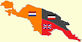
German New Guinea (German: Deutsch-Neuguinea) consisted of the northeastern part of the island of New Guinea and several nearby island groups, and was part of the German colonial empire. The mainland part of the territory, called Kaiser-Wilhelmsland, became a German protectorate in 1884. Other island groups were added subsequently. The Bismarck Archipelago (New Britain, New Ireland and several smaller islands), and the North Solomon Islands were declared a German protectorate in 1885. The Caroline Islands, Palau, and the Mariana Islands (except for Guam) were bought from Spain in 1899. German New Guinea annexed the formerly separate German Protectorate of Marshall Islands, which also included Nauru, in 1906. German Samoa, though part of the German colonial empire, was not part of German New Guinea.
Following the outbreak of the First World War in 1914, Kaiser-Wilhelmsland and nearby islands fell to Australian forces, while Japan occupied most of the remaining German possessions in the Pacific. The mainland part of German New Guinea (Kaiser-Wilhelmsland), the Bismarck Archipelago and the North Solomon Islands are now part of Papua New Guinea. The Northern Mariana Islands are an unincorporated territory of the United States. The Carolines (as the Federated States of Micronesia), the Marshall Islands, Nauru and Palau are independent countries.
The islands to the east of Kaiser-Wilhelmsland, on annexation, were renamed the Bismarck Archipelago (formerly the New Britannia Archipelago) and the two largest islands renamed Neupommern ('New Pomerania', today's New Britain) and Neumecklenburg ('New Mecklenburg', now New Ireland). Due to their accessibility by water, however, these outlying islands were, and have remained, the most economically viable part of the territory. (Full article...)


Did you know (auto-generated)

- ... that artifacts of Papua New Guinean art were called "living spirits with fixed abodes"?
- ... that in 1984, more than 10,000 Papuans from West Papua crossed into Papua New Guinea as refugees due to a government crackdown?
- ... that David Dexter, who wrote the New Guinea volume in the series Australia in the War of 1939–1945, was a commando who served in East Timor and New Guinea?
- ... that Dorkas Tokoro-Hanasbey, the only female member of the New Guinea Council, arrived thirty minutes late to her inauguration ceremony?
- ... that Australiformis semoni is a parasite that infests marsupials in Australia and New Guinea and whose infestation could cause debilitating ulcerative granulomatous gastritis?
- ... that Australian official Jack Emanuel was awarded the George Cross in 1971 after being stabbed to death whilst trying to resolve a land dispute with the Tolai people of New Guinea?
General images -
-
 New Guinea from 1884 to 1919. Germany and Britain controlled the eastern half of New Guinea. (from History of Papua New Guinea)
 -
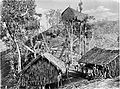 Koiari village near Bootless Inlet, British New Guinea (from History of Papua New Guinea)
 -
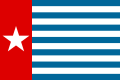 Since 2002, display of the flag of West Papua is allowed in West Papua only if accompanied by, and not raised higher than, the flag of Indonesia. (from Western New Guinea)
 -
 Yali Mabel, Kurulu Village War Chief at Baliem Valley (from New Guinea)
 -
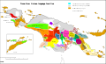
 Political divisions of New Guinea (2006) (from New Guinea)
 -
 Handover ceremony of West Irian Governorship from Jan Bonay to Frans Kaisiepo, 1965 (from Western New Guinea)
 -
 Sentani International Airport in Jayapura is the principal point of entry to Papua (from Western New Guinea)
 -

-
 Mount Bosavi (from New Guinea)
 -
 Fort Du Bus in 1828 (from Western New Guinea)
 -
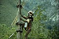
 Yali in the Yahukimo Regency (from Western New Guinea)
 -
 Highlands of Papua New Guinea (from New Guinea)
 -

-
 A section of Trans-Papua Highway connecting Deiyai and Mimika in Central Papua (from Western New Guinea)
 -
 New Guinea Volunteer Rifles with captured Japanese flag, 1942 (from History of Papua New Guinea)
 -
 Map of New Guinea, with place names as used in English in the 1940s (from New Guinea)
 -
 An Australian soldier, Private George "Dick" Whittington, is aided by Papuan orderly Raphael Oimbari, near Buna on 25 December 1942. (from History of Papua New Guinea)
 -
-
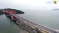 Youtefa Bridge, currently the longest bridge in Papua (from Western New Guinea)
 -
 New Guinea crocodile (from New Guinea)
 -
 A 1644 map of New Guinea and the surrounding area (from New Guinea)
 -
 Dutch colonial civil servant in the Baliem Valley, 1958 (from Western New Guinea)
 -
 West Papuan separatists raising the Morning-Star flag in the jungles of Papua, 1971 (from Western New Guinea)
 -
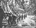
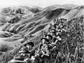 Australian soldiers resting in the Finisterre Ranges of New Guinea while en route to the front line (from New Guinea)
 -
 Papeda, a notable dish originating from Eastern Indonesia (from Western New Guinea)
 -
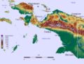
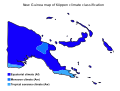 Papua New Guinea map of Köppen climate classification (from New Guinea)
 -
 The floristic region of Malesia (from New Guinea)
 -

-
A typical map from the Golden Age of Netherlandish cartography. Australasia during the Golden Age of Dutch exploration and discovery (ca. 1590s–1720s): including Nova Guinea (New Guinea), Nova Hollandia (mainland Australia), Van Diemen's Land (Tasmania), and Nova Zeelandia (New Zealand). (from History of Papua New Guinea)
-
 Hoisting the German flag at Mioko in 1884 (from History of Papua New Guinea)
 -
 Kerepunu women at the marketplace of Kalo, British New Guinea, 1885 (from History of Papua New Guinea)
 -
 Australian troops at Milne Bay, Papua.The Australian garrison was the first to inflict defeat on the Imperial Japanese Army during World War II at the Battle of Milne Bay of Aug–Sep 1942. (from History of Papua New Guinea)
 -
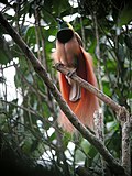
 The king bird-of-paradise is one of over 300 bird species on the peninsula. (from Western New Guinea)
 -

-
![Image 35M.S. Rumagesan, Silas Papare, N.L.Suwages, Soegoro Atmoprasodjo [id], and A.H. Nasution in Putra-putra Irian Barat ('Sons of Irian Barat') Conference in Cibogo Bogor, 14–15 April 1961 (from Western New Guinea)](https://upload.wikimedia.org/wikipedia/commons/thumb/7/74/MS_Rumagesan%2C_Silas_Papare%2C_NL_Suwages%2C_Sugoro%2C_dan_AH_Nasution_berbincang-bincang%2C_Konferensi_Cibogo.jpg/120px-MS_Rumagesan%2C_Silas_Papare%2C_NL_Suwages%2C_Sugoro%2C_dan_AH_Nasution_berbincang-bincang%2C_Konferensi_Cibogo.jpg) M.S. Rumagesan, Silas Papare, N.L.Suwages, Soegoro Atmoprasodjo, and A.H. Nasution in Putra-putra Irian Barat ('Sons of Irian Barat') Conference in Cibogo Bogor, 14–15 April 1961 (from Western New Guinea)
M.S. Rumagesan, Silas Papare, N.L.Suwages, Soegoro Atmoprasodjo, and A.H. Nasution in Putra-putra Irian Barat ('Sons of Irian Barat') Conference in Cibogo Bogor, 14–15 April 1961 (from Western New Guinea) -
 Topographical map of New Guinea (from New Guinea)
 -
 Free West Papua protest in Melbourne, Australia, August 2012. (from Western New Guinea)
 -
New Guinea from 1884 to 1919. The Netherlands controlled the western half of New Guinea, Germany the north-eastern part, and Britain the south-eastern part. (from New Guinea)
-
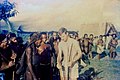
 Dutch and Papuan officials during the opening of the Central Hospital in Hollandia, 1959 (from Western New Guinea)
 -
-
 Dutch expeditions in Netherlands New Guinea 1907–1915. (from Western New Guinea)
 -
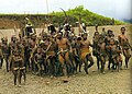
 Culture parade in Biak (from Western New Guinea)
 -
 Trans-New Guinea languages (multi-coloured), Austronesian languages (gold), and other languages (grey) (from Western New Guinea)
 -
 Fishing boats in Biak (from Western New Guinea)
 -
 Coral reefs in Papua New Guinea (from New Guinea)
 -
 The Sukarno-era West Irian Liberation Monument in Lapangan Banteng, Jakarta. (from Western New Guinea)
 -
-
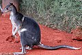 Dorcopsis hageni, native to northern region of New Guinea. (from Western New Guinea)
 -
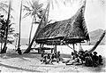 Group of natives at Mairy Pass. Mainland of British New Guinea in 1885. (from New Guinea)
 -
 The lowland rainforest of the Western New Guinea (from Western New Guinea)
 -
 Australian forces attack Japanese positions during the Battle of Buna–Gona, 7 January 1943. (from History of Papua New Guinea)
 -
 British flag raised in Queensland 1883 (from History of Papua New Guinea)
 -
 Flag under German control of New Guinea. (from History of Papua New Guinea)
 -
 Rp 0.12 Indonesian stamp of 1963. (from Western New Guinea)
 -
 Sago is a typical Papuan food, which is usually made into papeda. (from Western New Guinea)
 -
 Regions of Oceania: Australasia, Polynesia, Micronesia, and Melanesia. Physiographically, Australasia includes the Australian landmass (including Tasmania), New Zealand, and New Guinea (from New Guinea)
 -
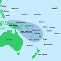 New Guinea located in relation to Melanesia (from New Guinea)
 -

-
 The Nagarakertagama mentioned a region in the east called Wanin, present-day Onin Peninsula in the Fakfak Regency, West Papua (from Western New Guinea)
 -
 Paradisaea apoda, native to Papua, displaying its feathers (from Western New Guinea)
 -
 Grasberg Mine in Mimika Regency. Mining is the most important sector in the province (from Western New Guinea)
 -
 Australian patrol officer in 1964 (from History of Papua New Guinea)
 -
 The raggiana bird-of-paradise is native to New Guinea. (from New Guinea)
 -
 A Japanese military map of New Guinea from 1943 (from New Guinea)
 -
 Female gable image, Sawos people, Oceanic art in the Bishop Museum (from History of Papua New Guinea)
 -
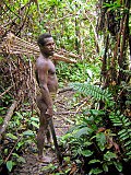
Korowai tribesman (from New Guinea)
-
 Skouw border checkpoint, on the Indonesia-Papua New Guinea border (from Western New Guinea)
 -
 Papuans on the Lorentz River, photographed during the third South New Guinea expedition in 1912–13 (from New Guinea)
 -
 Jayapura, the most populous and largest city on the island of New Guinea (Papua) (from New Guinea)
 -
Dutch expeditions in Netherlands New Guinea 1907–1915. (from Western New Guinea)
-
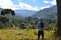
 The rugged and mountainous topography of Western New Guinea. (from Western New Guinea)
 -
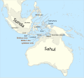 Map showing the combined landmass of Sahul formed during Pleistocene glacations (from New Guinea)
 -
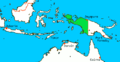 Western New Guinea was formally annexed by Indonesia in 1969. (from New Guinea)
 -
The continent of Sahul before the rising ocean sundered Australia and New Guinea after the last ice age (from New Guinea)
-
Regions of Oceania: Australasia, Polynesia, Micronesia, and Melanesia. Australasia includes the Australian landmass (including Tasmania), New Zealand, and New Guinea. (from History of Papua New Guinea)


![Image 35M.S. Rumagesan, Silas Papare, N.L.Suwages, Soegoro Atmoprasodjo [id], and A.H. Nasution in Putra-putra Irian Barat ('Sons of Irian Barat') Conference in Cibogo Bogor, 14–15 April 1961 (from Western New Guinea)](https://authorpaedia.org/jesse-ventura/?rdp_we_resource=https%3A%2F%2Fen.wikipedia.org%2Fwiki%2FFile%3AMS_Rumagesan%2C_Silas_Papare%2C_NL_Suwages%2C_Sugoro%2C_dan_AH_Nasution_berbincang-bincang%2C_Konferensi_Cibogo.jpg)


Related portals
WikiProjects
General topics
Categories

Associated Wikimedia
The following Wikimedia Foundation sister projects provide more on this subject:
-
 Commons
Free media repository -
 Wikibooks
Free textbooks and manuals -
 Wikidata
Free knowledge base -
 Wikinews
Free-content news -
 Wikiquote
Collection of quotations -
 Wikisource
Free-content library -
 Wikiversity
Free learning tools -
 Wiktionary
Dictionary and thesaurus
External media

More portals


