Ehsan Danish
Tecámac | |
|---|---|
Town & Municipality | |
Clockwise, from top: Municipal palace, Universidad Tecnológica de Tecámac, San Pedro Xolox, Our Lady of Candelaria Parish Church, Auditorio Metropolitano de Tecámac, Tecámac Power Center | |
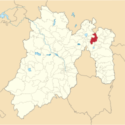
 Location of the municipality in Mexico State | |
| Coordinates: 19°42′47″N 98°58′06″W / 19.71306°N 98.96833°W | |
| Country | |
| State | |
| Region | Ecatepec Region |
| Metro area | Greater Mexico City |
| Municipal Status | September 12, 1825[1] |
| Municipal Seat | Tecámac de Felipe Villanueva |
| Government | |
| • Type | Ayuntamiento |
| • Municipal President | Rocío Díaz Montoya |
| Area | |
• Total | 157.34 km2 (60.75 sq mi) |
| • Land | 157.34 km2 (60.75 sq mi) |
| • Water | 0.00 km2 (0.00 sq mi) |
| Elevation | 2,260 m (7,410 ft) |
| Population (2020) | |
• Total | 547,500 |
| Time zone | UTC-6 (CST) |
| Postal code (of seat) | 55740 |
| Area code | 55 |
| Demonym | Tecamaquense |
| Website | Official website (in Spanish) |
Tecámac is a municipality in State of Mexico in Mexico. The municipality covers an area of 157.34 km². The municipal seat lies in the town (locality) of Tecámac de Felipe Villanueva. Its largest town, Ojo de Agua, with a population of 242,283 inhabitants, is the largest locality in Mexico that is not a municipal seat.
As of the 2020 census, the municipality had a total population of 547,500, with most people residing in Ojo de Agua.
Geography

The town of Tecámac de Villanueva, a municipal seat, has governing jurisdiction over the following communities: Ozumbilla, Santa María Ajoloapan, San Lucas Xolox, Los Reyes Acozac and Ojo de Agua. The total municipality extends 157.34 km2 and borders with the municipalities of Zumpango, Temascalapa, Tonanitla, Teotihuacán and Ecatepec de Morelos.
Infrastructure
Felipe Ángeles International Airport is located within the municipalities Zumpango and Tecámac.
Tecámac Power Center is an important shopping destination for Tecámac and surrounding municipalities, 812,000 square feet (75,400 m2) in area, anchored by Cinépolis cinemas, FunCentral (entertainment area), Home Depot, Sam's Club, Suburbia, and Walmart.[2][3]
Politics
| Mayor | Time |
|---|---|
| Aaron Urbina Bedolla | 2012–2015 |
| Rocío Díaz Montoya | 2016– |
Demography
The largest localities (cities, towns, and villages) are:[4]
| Populated place | 2010 Census Population |
|---|---|
| Ojo de Agua | 242,283 |
| San Martín Azcatepec | 35,390 |
| Los Reyes Acozac | 21,910 |
| Santa María Ajoloapan | 17,784 |
| Tecámac de Felipe Villanueva | 15,911 |
| San Lucas Xolox | 20,478 |
| Fraccionamiento Social Progresivo Santo Tomás Chiconautla | 15,061 |
| Total Municipality | 364,590 |
References
- ^ "Bando Municipal de Tecámac 2015" (PDF). H. Ayuntamiento de Tecámac 2013-2015. Retrieved September 9, 2015.
- ^ "Tecámac Power Center", Fibra MacQuarie website
- ^ Tecámac Power Center official website
- ^ 2010 census tables: INEGI Archived 2013-05-02 at the Wayback Machine

 Read
Read
 AUTHORPÆDIA is hosted by Authorpædia Foundation, Inc. a U.S. non-profit organization.


