
 AUTHORPÆDIA is hosted by Authorpædia Foundation, Inc. a U.S. non-profit organization.
Ace Atkins
| Spindle Geyser | |
|---|---|
 | |
| Location | Lower Geyser Basin, Yellowstone National Park, Teton County, Wyoming |
| Coordinates | 44°31′54″N 110°47′44″W / 44.5316008°N 110.7954883°W[1] |
| Elevation | 7,346 feet (2,239 m)[2] |
| Type | Fountain geyser |
| Eruption height | 1-10 feet |
| Frequency | 1-3 minutes |
| Duration | few seconds |
| Temperature | 89.3 °C (192.7 °F)[1] |
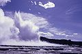
Spindle Geyser is a geyser in the Lower Geyser Basin of Yellowstone National Park in the U.S. state of Wyoming.
Spindle Geyser is part of the White Creek Group which includes A-0 Geyser and Botryoidal Spring. It is found along the bank of White Creek about 1⁄2 mile (0.8 km) southeast of the Surprise Pool parking area.[3]
It erupts for a duration of a few seconds with an interval of 1–3 minutes between eruptions. Eruptions tend to be small, sometimes no more than a vigorous roiling of the pool but can reach 1 to 3 feet (0.3 to 0.9 m). Prior to 1985, Spindle had eruptions as large as 10 feet (3.0 m). Spindle also generates subterranean thumps that can be felt when standing near the geyser.[3]
References
- ^ a b "Spindle Geyser". Yellowstone Geothermal Features Database. Montana State University.
- ^ "Spindle Geyser". Geographic Names Information System. United States Geological Survey, United States Department of the Interior.
- ^ a b "Spindle Geyser". Geyser Observation and Study Association (GOSA).
Yellowstone National Park - Lower and Midway Geyser Basins | ||
|---|---|---|
Geothermal features, geography, historic structures and other attractions in the Lower and Midway Geyser Basins | ||
| Lower Geyser Basin |
|  |
| Midway Geyser Basin | ||
| Structures and history | ||
| Geography and geology | ||